
BCP must plan for 2,980 homes a year, almost triple the 1,100 built last year. Town sites fall 14,100 short, so Green Belt north of Bournemouth is in play.
BCP Council says it cannot fit the homes the government requires inside the existing towns. It will ask residents in October about releasing Green Belt land on the northern edge of Bournemouth, Poole and Christchurch.
The council’s Cabinet meets on Wednesday 30 September to approve the next Local Plan consultation. The Cabinet report and the 81-page consultation document were published with the meeting agenda.
The numbers in the council’s own evidence
The government’s standard method sets BCP a need of 2,980 homes a year. Over the 15-year plan, from 2029 to 2044, that is 44,700 homes.
The council has assessed more than 1,000 possible sites. Its draft findings are:
- sites inside the existing urban area could provide around 30,600 homes
- that leaves a shortfall of around 14,100 homes
- Green Belt sites put forward by landowners and developers could provide around 7,800 homes
- even with all of those, there would still be a shortfall of around 6,200 homes
The document says the figures are “indicative at this stage” and will be refined.
It also records that Dorset Council has said it is “unlikely to be able to accommodate any of BCP Council’s unmet housing need”. Dorset is struggling to meet its own, substantially increased housing requirement.
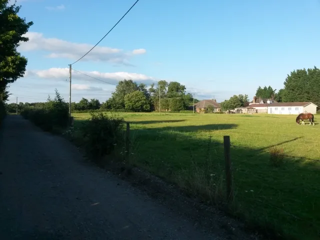
Where the Green Belt land is
The document says potential urban extensions on Green Belt land “exist across the northern parts of the BCP area in north Poole, north Bournemouth and to the north of Christchurch”.
It does not name individual sites. Those will be shown on interactive maps in the consultation, as part of the council’s Land Availability Assessment.
The council is careful to say that listing a site decides nothing. The assessment “does not in itself determine whether a site should be allocated for development”, according to the Cabinet report.
A separate Green Belt review, also due to be published in October, found that many areas of Green Belt in BCP “make a strong contribution to preventing settlement coalescence”. In plain terms, they stop towns and villages merging.
Nearly three times what is being built now
The 2,980 figure is far above what the area has been delivering. Government figures in Live Table 122 show BCP added a net 1,100 homes in 2024-25. The year before it was 912.
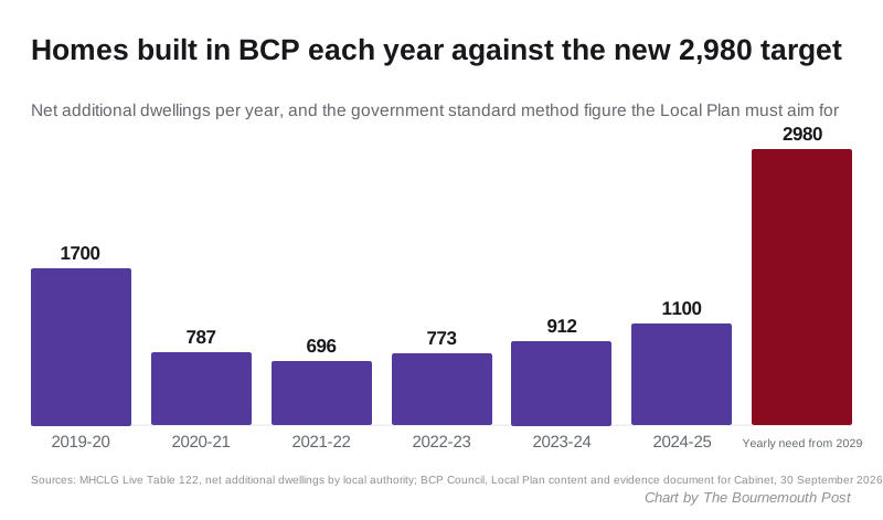
Over the five years to March 2025, BCP averaged about 854 net new homes a year. The new figure is three and a half times that.
What else the plan would set
The consultation document lists ten measurable outcomes. Among them:
- 70% of new homes and jobs directed into the existing urban area
- at least 40% affordable housing on qualifying sites
- at least 17 permanent Gypsy and Traveller pitches
- around 86 hectares of new employment land
- half of all trips made on foot, by bike or by public transport by the end of the plan
- vacancy rates in Bournemouth, Poole and Christchurch town centres kept below 20%
The council’s housing needs assessment puts the need for affordable homes at around 27,500 over the plan period. That is more than half the total target.
Second homes and holiday lets
Residents often ask why second homes are not counted against the shortfall. The document gives the local figures:
- around 2,300 short-term let listings in the BCP area
- around 5,000 second homes, from council tax records
It says the council “has no planning powers to return them to permanent residential use”.
Why this is happening now
BCP withdrew its last Local Plan in June 2025, on the advice of the Planning Inspectorate. It began again under the government’s new plan-making system, with a scoping consultation that ran from 15 June to 27 July 2026. That drew around 180 responses, according to the Cabinet report.
All of the area’s adopted Local Plans are more than seven years old. The report warns that delay would leave the council facing “unplanned/speculative development pressures, including those on Green Belt sites”.
Council leader Millie Earl said in the council’s announcement: “Nothing is decided yet. No final decisions have been made on sites.”
The timetable
| Stage | Date |
|---|---|
| Cabinet decision on this consultation | 30 September 2026 |
| Consultation on plan content and evidence | October to November 2026, at least six weeks |
| Consultation on the draft Local Plan | September to November 2027 |
| Submission for examination | May 2028 |
| Examination | June to November 2028 |
| Adoption (indicative) | January 2029 |
Source: Cabinet report, 30 September 2026.
What it means for you
- If you live near open land on the northern edge of Bournemouth, the October consultation is the first time you will see which sites are on the table. The interactive maps are where to look.
- You can comment for at least six weeks once it opens. Key documents will also be in libraries, with face-to-face drop-in sessions, the report says.
- A site on the map is not an allocation. Sites are chosen for the draft plan in 2027, and that draft is consulted on again.
- Landowners can still put sites forward, because a fresh call for sites runs alongside the consultation.
We will report the Cabinet decision on 30 September and link the consultation when it opens. For the applications already in the system, see our Bournemouth planning news.
Have your say